Haarlem sits about 12 miles from Amsterdam to the southeast and about 7 miles from the North Sea to the west.
 |
| Haarlem, 2018 |
The train station, Haarlem Centraal, is situated on the north end of the old city. Trains run to all points -- north, south, east and west -- many times daily; trips to either Amsterdam or out to Zandvoort take merely 15 minutes.
 |
| Haarlem, circa 1550 |
On the north end, outside the walls, was the Het Dulhuys. In Dutch, dul means crazy and huys is an old spelling for huis or house. Essentially, this was a leper community created in 1413. Apparently people from all over Noord-Holland came here to be tested and treated. Today the building is a national museum for psychiatry.
In the southwest corner of this map were the bleaching grounds. Here, linen sheets were brought out to the field to be bleached by the sun and water. This was an important part of a textile community, of which Haarlem was one in the vast trade network between England, Europe and Asia in the late Renaissance and early modern periods.
 |
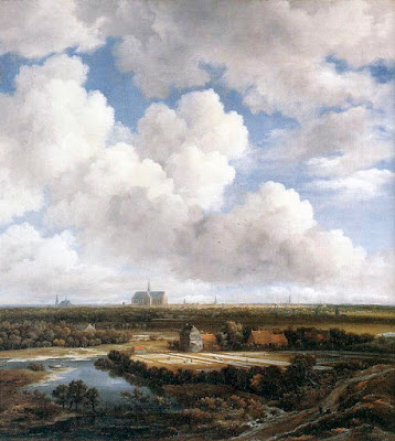
| View of Haarlem with Bleaching Grounds, c 1665 Jacob van Ruisdael Oil on canvas, 62 x 55 cm Kunsthaus, Zurich |
Ruisdael is known for his technique in producing an open perspective; this image is one of the best examples of it.
Yet even as the viewer gains a detailed look at the Dutch landscape, more than half of the image is sky and clouds.
This is characteristic of Dutch landscape artists of the period but Ruisdael has outdone himself with the alternating bands of light and dark, drawing the eye upwards and out.
Is this heaven we are to think about? Or simply the blessing of land and sky in a water logged nation?
And these clouds that Ruisdael and so many of his artist compatriots were painting 400 years ago can still be seen today.
Indeed, I have been wandering around the Dutch countryside for five weeks now and am continually amazed with the beauty of the clouds everywhere and at all times, whether sunrise, during mid-day, or at sunset. It's no wonder they used so much canvas on the clouds, for there is enduring, almost heartbreaking beauty in their ethereal composition. Here's my look from just this afternoon.
 |
| River Spaarne and Haarlem Old City |

No comments:
Post a Comment